The Next Generation of AI-Driven Location Intelligence Technology
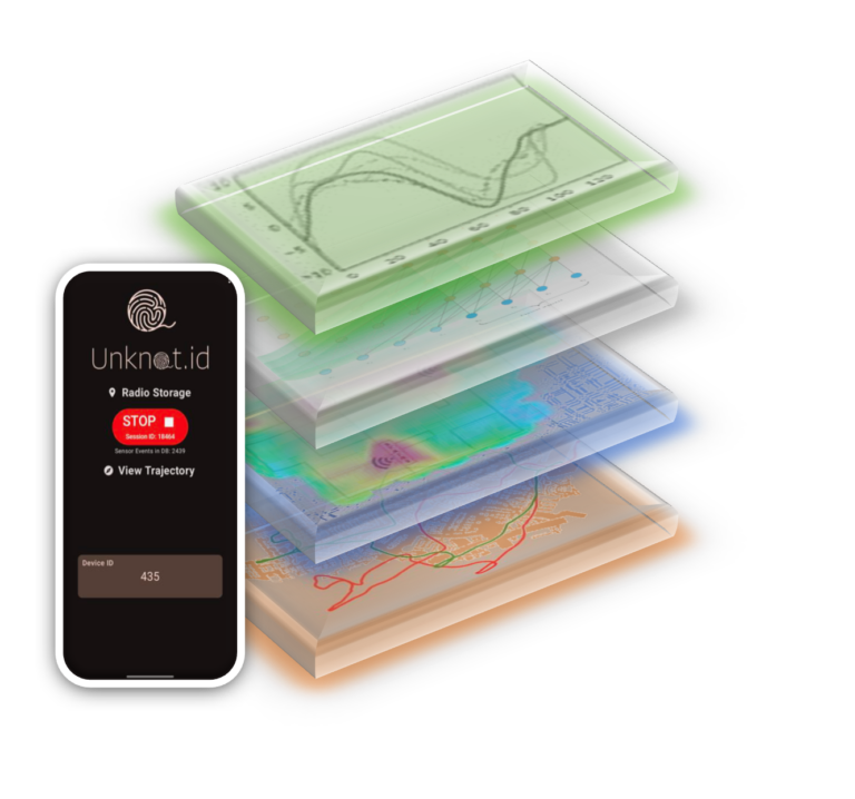
Unknot.id’s Fuse AI™ is an AI-driven software solution that uses multi-sensory tracking to deliver reliable, realtime 3D positioning data across any environment.
Most positioning technology is either expensive, unreliable, inaccurate- or all three. From limited GPS range to expensive beacon installations, organizations are forced to settle for unreliable signals and excessive infrastructure costs.
Fuse AI™ is the first true solution to this problem, covering all your tracking needs with a single piece of software that requires no additional infrastructure.
Turn Noisy Signals into Precise Navigation
Our multi-modal AI solution transforms noisy sensory inputs into accurate location data:
Precise navigation that works everywhere – from multi-level tracking across large buildings to complex urban environments, forests and caves
Automatically identifies your starting point to locate individuals or assets
Delivers indoor geopositioning as well as reliable outdoor tracking, with the capacity to track the asset or person’s floor level
Meeting Real Time Location Needs
Lower Costs
Fuse AI™ replaces satellites, beacons, and specialized sensors with a single cost-effective software solution.
Accurate Signal
Fuse AI™ avoids reliance on a single sensor modality to enable accurate 3D tracking, even within crowded and GPS-denied environments.
Seamless Scalability
Fuse AI™ is easy to install, deploy, and scale, integrating with legacy systems and requiring zero additional infrastructure.
Who We Serve
Defense
FOR DEFENSE AND MILITARY ORGANIZATIONS
From real-world battlefields to training environments, Unknot.id provides unparalleled insight at unprecedented low costs:
Gain reliable 3D positioning within regions where GPS is denied, or enemies interfere with your intelligence
Eliminate the need to calibrate for individual personnels or deploy new hardware
Turn noisy signals into useful data using a single AI-driven software platform
Prepare for, mitigate, and avoid safety and operational risks and incidents by equipping your team with comprehensive intelligence within the most complex environments:
Identify personnel locations and optimally allocate resources faster
Post-mortem data covering and identifying anomalous behavior
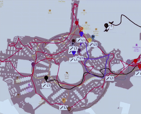
Access precise 3D tracking throughout multi-level buildings and heavily populated environments like stadiums, airports, office buildings, and university campuses
Integrate with legacy systems to avoid purchasing expensive new hardware or tracking infrastructure
”Unknot’s game changing technology not only enhances security but also offers crucial data for resource optimization, dispatch improvements and customer marketing – all contributing to greater efficiency, safety and enhancing revenue opportunities.”
CIO, DFW
“Unknot.id’s unique product continues to leave you in wonder, reshaping the landscape of tracking , monitoring and forensics.“
Chief Security Executive, Mohegan Tribe
Success Stories
Delivering Value for DFW Airport, Dallas
Project Goal
Enhance resource management tracking
Optimize wheelchair dispatch efficiency
Technical Challenges
Beacon installation would be too expensive
Existing systems were unable to track targets on trains or across multiple building levels
Results
Increased value with use of existing devices & Infrastructure
Worked flawlessly in multi-level, trains, and Walkways
Tracking accuracy within 3m
Achieving 30x Better Situational Awareness at Mohegan Sun Casinos
Project Goals
Enhance situational awareness
Faster incident response
Create efficiencies in resource allocation
Improve cumbersome incident investigation
Technical Challenges
GPS inaccurate by +50m
Beacons required +$5 million investment
Inability to track floor-to-floor
Results with Unknot.id
30x Better Situational Awareness with 0.3m – 3m accuracy
Flawless Level Detection
15x ROI with use of existing devices & Infrastructure
Equipping the Department of Defense (DoD) with 100% Available, Resilient, and Robust Tracking
Project Goals
Reduce reliance on GPS
Keep soldiers safe and secure and operate efficiently in GPS-contested regions
Enable navigation across all indoor and outdoor environments
Technical Challenges
Uncertain operational environments for various use cases ranging from seen to completely unseen and dynamic environments (Training Exercises, Tactical Operations in Adversarial environments)
Demands very high accuracy (cm to sub-meter) for various applications (humans to assets)
Integration with existing platforms has proven difficult
Results with Unknot.id
Sub-meter accuracy and more in GPS-contested environments, with better availability and reliability compared to LiDAR and visual-only solutions
Eliminated the need to calibrate for user, position, or device categories
Easily integrates with smartphones, radios, extending to weapons, drones, ground vehicles
Enhanced battlefield situational awareness
Make Location Intelligence Your Secret Weapon
Want to explore how 3D positioning with sub-meter error rates could help your organization improve tracking, enhance revenue, and reduce costs?